Trusted 3D Mapping & Survey Accuracy Call 770-608-5725

Trusted 3D Mapping & Survey Accuracy Call 770-608-5725
LiDAR Data Creates Digital Representation

LiDAR (light detection and ranging) is a remote sensing method that can detect objects and place in real space while accurately measuring the surface of the earth with exact precision. Drones equipped with LiDAR and other instrumentation measure the light’s reflection and range from an object’s surface to an object across millions of beams. That data is electronically compiled with GPS technology and data from the drone’s inertial measurement unit (IMU) to create a digital file called a point cloud. A professional surveyor can then turn this point cloud into a number of different final products including contour files, 3D maps, etc.
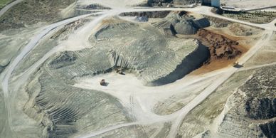
By combining traditional methods of data collection with drone data collection, mappers and surveyors can reap a number of benefits.

Our drone technology can be used for surveying and monitoring construction sites, providing detailed images and videos that can be used for progress tracking, safety inspections, and more.
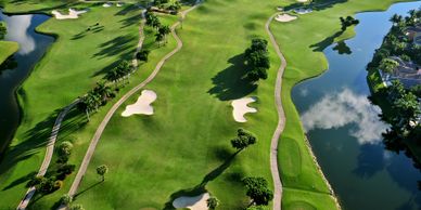
Enhance golf course operations with detailed aerial imagery for planning and maintenance.

Unique drone services tailored to your project. Contact us today.
In today’s commercial property environment, decisions need to be faster, more accurate, and backed by real data. Traditional site visits, manual measurements, and basic aerial photos are no longer enough.
That’s where 3D drone mapping comes in.
At Brown’s Aerial Photography, we provide high-resolution 3D mapping solutions that give property managers, roofing contractors, and developers a complete digital view of their assets - without the risk, guesswork, or wasted time.
What is 3D Drone Mapping?
3D drone mapping uses advanced photogrammetry to capture hundreds of overlapping aerial images and convert them into:
This isn’t just imagery - it’s actionable data.

Instead of sending crews onto a roof or relying on rough estimates, you get:
Why it matters:
More accurate bids. Fewer change orders. Better margins.

You can:
Why it matters:
Clear visuals make decisions easier and faster.
With 3D mapping, you can:
Why it matters:
You move faster than competitors still relying on manual inspections.
This creates:
Why it matters:
If there’s ever a dispute, you have hard evidence.
3D drone mapping allows inspections to be completed:
Why it matters:
Lower liability. Safer operations. Smarter inspections.
Use it for:
Why it matters:
Better presentation = higher perceived value.
The shift is simple:
Companies that adopt this technology early gain a clear competitive advantage.
Welcome! Please contact us if you have any questions. 770-608-5725